Quarries. Position of Sign A
Dublin Core
Title
Quarries. Position of Sign A
Language
en
Identifier
ALK.18.00.02
Is Part Of
Point Item Type Metadata
Latitude
40.60171
Longitude
24.74034
MobileContent
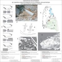
At this point, we see the explanatory sign of the archaeological service. It includes a topographical drawing of the early Christian quarries and designs where the various quarrying techniques are explained during the historical period. Moreover, a graphical representation shows the use and the transfer techniques of marbles, in the wider area. In addition, noticeable positions and findings of the area are presented.
SpeechContent
At this point,, we see the explanatory sign of the archaeological service. It includes a topographical drawing of the early Christian quarries, and designs where the various quarrying techniques are explained, during the historical period. Moreover, a graphical representation shows the use, and the transfer techniques of marbles, in the wider area. In addition, noticeable positions and findings of the area, are presented.
Entrance
TextDuration
0:26
Files
Collection
Citation
“Quarries. Position of Sign A,” iGuide Repo, accessed December 5, 2025, http://ubuntu01.ceti.gr/omeka/items/show/1797.
Item Relations
| This Item | dcterms:isPartOf | Item: Quarries. Position of Sign A |

